Ravenna Creek Historic Change
This diagram illustrates the drastic ecological changes that White settlement has wreaked on Ravenna Creek (although the changes to Ravenna Creek are representative of changes to waterways throughout the region).
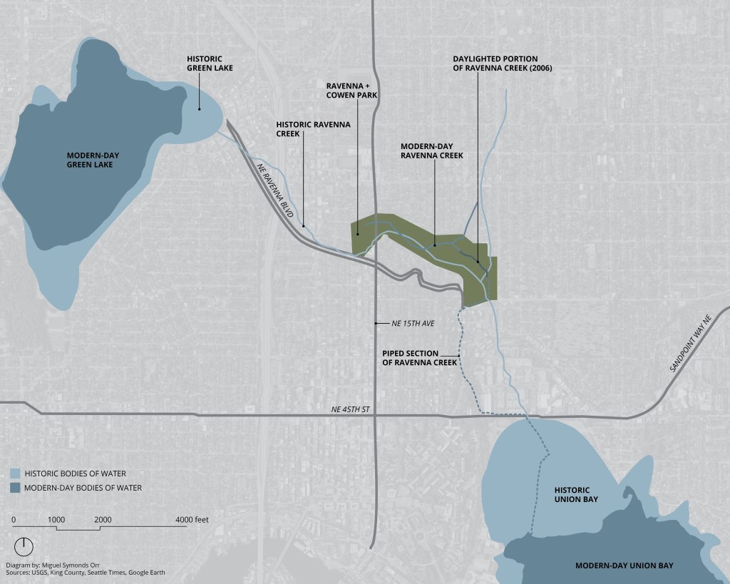
Before European settlement, what is now known as Ravenna Creek flowed from Green Lake through Ravenna Ravine and into Union Bay. However, John Charles Olmsted, in his plan for Seattle’s parks, suggested that Green Lake be lowered to make a more suitable park. The City of Seattle took Olmsted’s advice and ran with it, lowering Green Lake more than he suggested and cutting off Ravenna Creek’s inlet from Green Lake. This essentially turned the beginning of Ravenna Creek into a wetland. Further changes involved piping Ravenna Creek toward the end of the park underground, where it now flows to Union Bay. In 2006, a portion of Ravenna Creek within the park was daylighted, but most of it remains underground. This project tells this story visually, highlighting how severely Seattle’s waterways have been impacted.
At Union Bay, many changes occurred to make the bay more amenable for industry, but that’s out of the scope of this project. If this topic interests you, I recommend you read some of the resources linked below or more historylink.org articles.
Note: the historic and present-day Ravenna Creek paths do not line up in this diagram. I do not know if this was a surveying error, a change of the flow over time, or an error on my part.
Sources & Further Reading:
HistoryLink article on Ravenna – comprehensive article of the park’s history: https://www.historylink.org/File/9559
Ravenna Creek Daylighting in 2006:
Bush – Ravenna Creek Finally Ready to See Daylight (2003):
https://archive.seattletimes.com/archive/?date=20050702&slug=ravenna02m
http://parkprojects.com/2003news/0311nov/newsrave.html
Website by the designer – http://www.gaynorinc.com/ravenna-creek-daylighting-in-ravenna-park-seattle-wa
Ravenna Creek Drop Project tracing creek’s route from Ravenna to Union Bay: https://www.mbvkstudio.com/ravenna-creek-project
Article with historical photos of Ravenna Creek: https://pauldorpat.com/2009/08/09/cowens-university-park-a-thing-of-beauty-is-a-joy-forever-keats/
Ravenna Park History written in 1968: http://clerk.seattle.gov/~F_archives/sherwood/RavennaPk.pdf
Location: Seattle, Washington
Year: Autumn 2022, Updated 2022-24
Class: L ARCH 401: Design Foundations Studio
Data From: USGS, King County Settle Times. Google Earth
1856 large hydrology map https://www.blm.gov/or/landrecords/survey/yPlatView1_2.php?path=PWA&name=t250n040e_001.jpg
USGS Maps of Seattle: https://ngmdb.usgs.gov/topoview/viewer/#13/47.6682/-122.3189
King County 2010 Ravenna Creek Transfer Pipe Extension Project: https://kingcounty.gov/~/media/depts/dnrp/wtd/capital-projects/COMPLETED/Ravenna/doc/1003_RavennaSEPAflier.ashx?la=en
