Homelessness and Social Equity
This collage and this map speak to the injustice of Seattle’s homelessness crisis in two ways; one draws links to the displacement and exclusion of unhoused people to the historic displacement and exclusion of Indigenous Coast Salish peoples in Seattle and the other spatially demonstrates how far Seattle is from meeting the needs of its unhoused population. Both served as thematic inspiration for my L ARCH 300 final project.
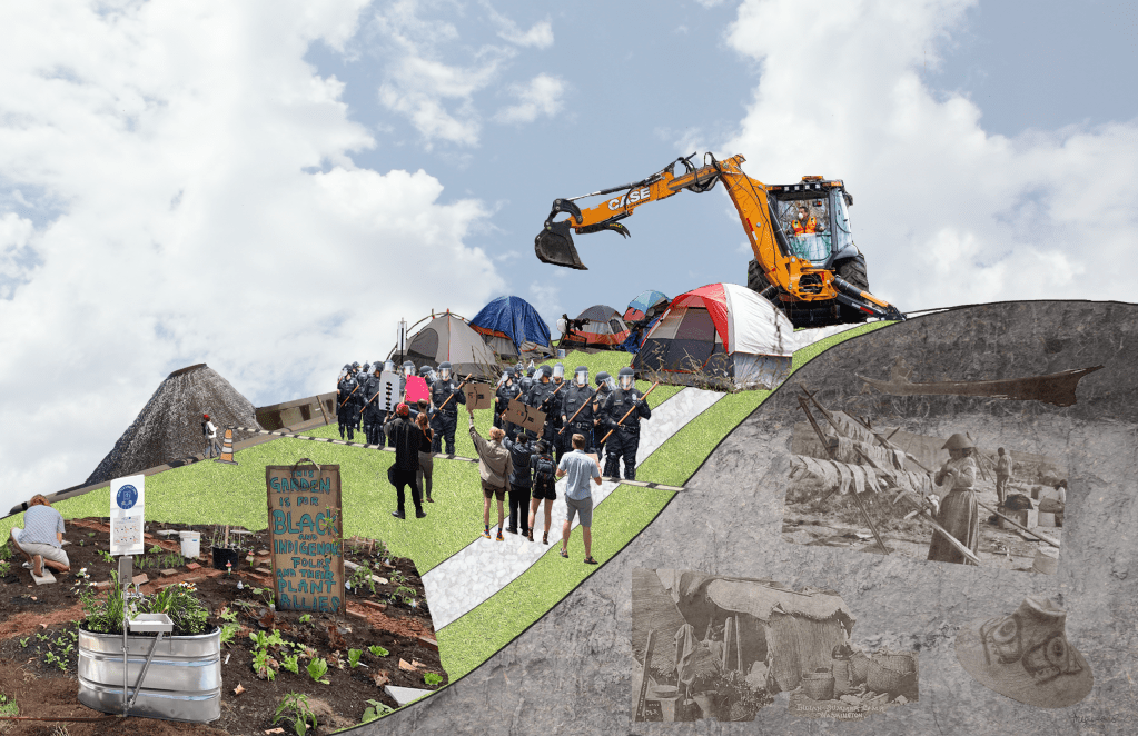
The collage explores interlinked contemporary and historic conflicts within parks. Parks are often designed as sites of leisure for the well-to-do and created through dispossession of Indigenous inhabitants (as in the case of National Parks, and, one could argue, any park on this continent) and other marginalized inhabitants. For instance, the majority Black working class inhabitants of Seneca Village were dispossessed and subsequently disenfranchised to create New York City’s famous Central Park. Despite these aspects of parks, they are often retooled into sites of healing and resistance. As shown in this collage, struggles over the rights of unhoused people to live in public space often occur at parks. Protests and encampments have been held at parks, such as those in the Occupy Wall Street movement or Seattle’s CHOP at Cal Anderson (the community garden for “Black and Indigenous folks and their plant allies” is featured in this collage).
As an aspiring landscape architect, I try to be cognizant of the different roles landscape architects have played throughout history and their relation to struggles for justice (or their suppression). We all have a role in collective liberation, and it’s important for us to examine how our own passions fit into that.
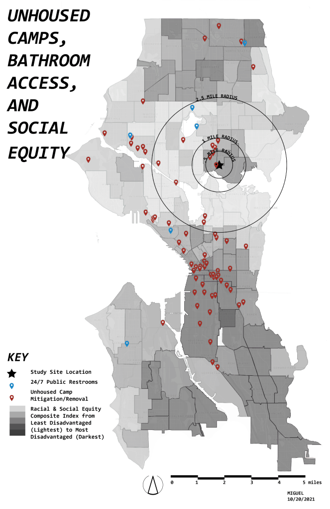
The map draws parallels between homelessness, proximity to hygiene services, and neighborhood wealth by combining the locations of sites where City of Seattle officials performed encampment mitigation and/or removal (in 2020), the locations of the six 24/7 public restrooms in Seattle (2019), and the City of Seattle’s Racial and Social Equity Composite Index (2020). Since many mitigation/removals are performed more than once, these locations may be read as common unhoused encampment sites. This data reveals that encampment sites are clustered in lower-income areas while the resources those encampments need are often concentrated in wealthier areas.
Sources & Further Reading:
Article on Seneca Village: https://www.centralparknyc.org/articles/seneca-village
The Atlantic – Return the National Parks to the Tribes: https://www.theatlantic.com/magazine/archive/2021/05/return-the-national-parks-to-the-tribes/618395/
Article on CHOP Garden: https://thecounter.org/black-lives-matter-blm-seattle-farmer-garden-chaz-chop/
S. Seattle Emerald Article about Sweeps: https://southseattleemerald.com/2021/06/14/sweeps-continue-in-seattle-perspectives-from-the-street/
Hygiene Services: https://www.seattle.gov/humanservices/services-and-programs/addressing-homelessness
Urban Rest Stop Info: https://urbanreststop.org/about/information/history/
Location: Seattle, Washington
Year: Autumn 2021
Class: L ARCH 300: Intro to Landscape Architecture Design Studio
Additional Credits: Data from: City of Seattle, The Urbanist
https://www.seattle.gov/homelessness/unauthorized-encampments/encampment-abatement
https://www.theurbanist.org/2019/03/15/map-of-the-week-restrooms-for-all/
Image Descriptions:
1: A collage featuring a grassy hill. In the foreground is the CHOP garden for Black and Indigenous folks. Beyond are protestors confronting police, who guard demolition equipment used to remove unhoused people’s tents. The inside of the hill is revealed on the right of the image, showing buried Indigenous artifacts and lifeways beneath the earth.
2: A map of Seattle divided into counties in grayscale. Darker counties are more socially disadvantaged than lighter counties. Many red dots cover the map, and a few blue dots are scattered across the map. Top to bottom on the left side, the map is titled with this post’s title, then contains the first section of this post’s text, then a key. A north arrow and 5 mile scale bar are in the bottom right.
